Natural View

Natural View

Monday, September 22, 2014

Historical and Tourist Spots of Lalmonirhat

Lalmonirhat:

Lalmonirhat district is situated at the north side border of Bangladesh. It is under the Rangpur Division. There are five Thana/Upazila in this district. They are Lalmanirhat Sadar, Aditmari, Kaliganj, Hatibandha and Patgram. The area of Lalmonirhat District is of 1241.46 km2. It is bounded by Koch Bihar and Jalpaiguri to the north, Rangpur Districtto the south, Kurigram District and Koch Bihar to the east, Nilphamari and Rangpur to the west.


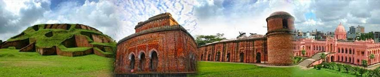
 Historical and Tourist Spots:
The common tourist spots of Lalmonirhat are Dohogram-Angarpota enclaves, Nidaria Mosque, Tushvandar Jamidarbari, Kakina Jamidarbari, Burimari Land port and Sector 6 Headquarter. 


Dahagram-Angarpota Enclave:

Dahagram and Angarpota enclave of Patgram upzila in Lalmonirhat district is the largest Bangladesh's enclaves inside India. A 'Passage Door' of the system was kept for communication with the enclaves and the mainland in Pakistan, which is currently known as 'Teen Bigha Corridor’. After 1985 the enclave Dahagram and Angarpota has become a distinct union of Patgram upzila in 19th of August 1989.  Teen Bigha Corridor is now opened for 24 hours after the deal signed at the meeting held in Dhaka between Bangladesh Prime Minister Sheikh Hasina and IndianPrime Minister Manmohan Singh on 6 September 2011.


Nidaria Mosque:

Mughal Subedar Mansur Khan had donated  10.56 acres of land and built the mosque in 1176 Hijree . At that tune Ijar Mahmud Sheikh, Bijar Mahmud Sheikh, Khan Mahmud Sheik was the motayalli of this mosque. There is a saying that people called this mosque as Nidariya Mosque because Subedar Mansur Khan has no beard. . At present the local people say pray in the mosque.


Tushvhandar Jamidar Bari:

TushVandar Jamidar bari is situatied at Tushvandar union in Kaligonj upzila. The ancestor of the Jamider Tushvander Murabi Dev Vhattacharga came to Cooch Behar from 24 Pargana din 1634 during the period of the great King Pran Narayan. At that time there was a system of donating land for religious loins. Murari Dev Ghoshal  did not accept the property as he was Brahmans rather he appealed to rent for the property. The rent was finally accepted as rice bran by the queen. According to legend, this place was known as Tush vhandar as a pile of collected husk. The Tushvhandar Jamidary was established by Brahman Murari Dev and ended by the death of Jamidar Girish Mohan Roy Chowdhury after the ruling of 4 hundred years.


Kakina estate:

According to the analysis of history, Kakina was a slice of Cooch Behar during the great king Modh Narayan. Indra Narayan Chakrabarty was the ruler of Kakina. In 1687 Fouzdar Ebadat Kha declared warship against Narayana Maharaja. The mission of the Mughals coach Behar  forces was defeated to the the Mughal and Indra Narayan catrubarti was suspended from the ruling of Kakina..


In 1687, the estate that was introduced through appointed Ram Narayan Choudhury as ruler of Kakina Parganas fallen in the face of destruction due to his overload reckless and luxuries spending. In 1925 his estate goes to auction because he had failed to pay arrears and government revenue and the management goes under the Court's orders. He left Kakina with his family almost destitute circumstances. He died in 1939 in Karshia

 Burimari Land port:
Burimari Land port is 457 km from capital Dhaka., 8 No Burimari Land port is one of the important land ports of Bangladesh. Many people come here to see the end of Bangladeshi border.


Sector 6 Headquarter:

During the liberation war in 1971, the 6 No headquarter was set up at Burimari union at patgram upzila in Lalmonirhat. 


Tista Bridge: 
One of the beautiful sopts of Lalmonirhat.


Dalailama Chara:


Sunday, September 21, 2014

Historical and Interesting spots of Thakurgaon, Bangladesh.

Thakurgaon


Thakurgaon is in the north west corner of Bangladesh, it is about 467 km from Dhaka, the capital of Bangladesh. It is surrounded by Dinajpur district on its south, Panchagarh district to the east and India on its west and north sides, it is a part of the Himalayan plain land.


History:

In the year 1800 During British rule A Thakur family established a thana beside the present municipality area.  The name Thakurgaon came from the respective family name. Thakurgaon was a district subdivision. In 1947 at the time of the Partition of India, Thakurgaon Subdivision became part of East Pakistan and became part of the newly established Dinajpur District of East Bengal. In 21st February, 1984 Takurgaon subdivision was split off Dinajpur and became a separate district- Thakurgaon with 5 Thana.

Interesting and Tourist Spots of Thakurgaon:  

 There are lot of historical and interesting tourist spots in Thakurgaon district. The most interesting places are the Jogdal Birendra Nath Choudhury's palace, Khuni dighi memorial monument, landlord Tankanath's house, Haripur Jamidar Bari, Ranisagar, Gorakhanath temple, Rajvita, Jogdal Rajbari, Mahalbari mosque, Jamalpur Jamidarbari mosque, Sangah Sahi mosque,  Harinmari Shib Mandir, Dholorhat temple,  Malduar fort, Gorgram fort, Bangla Gor, Gor Bhobanipur etc. 

Khunia Dighi memorial monument:


It is the largest men grave of Thakurgaon. During the liberation war of Bangladesh Pakistani army killed about 1000 people in this place. The area of the dighi is about 6 acrs.

  Haripur King's Palace:

Haripur Jamidar bari is the center of the Haripur upzilla. It was established by the generation. During the rule of muslim (i.e. 1400) a man named Ghansham Kunda came to Haripur to set up a business of Andy cloth. At that time a woman named Meherunnesa was the landlord of this area. She was from Medinisagar village. She had to paid to her taxes to the lord of Tajpur. Meherunnesa sold some part of her property to Ghansham Kunda due to her unpaid taxes.   
Raghbendra one of the descendants of Ghansham Kunda started to build up the Haripur king’s palace during the British period in 19th century. Jogendra Narayan, son of Raghbendra finished the construction of the king’s palace at the end of 19th century. The palace is a two stored building. The wall of the first floor was designed by different arabesque. The eastern wall contains 14 statue of Jogendra Narayan. There is a Shib temple at the eastern side of the building and a Nath temple in front of the temple. There was a big library in the king’s palace. 

Tonkonath Jamidar Bari: 


Tonkanath Jamidar Bari is located at Malduar beside the river Kulik which is the east of Ranishonkoil upzilla. The name of Tonkanath’s father is Buddinath Chowdhury. He was a Moithily Brahman and was the incharge of Shamrai temple inherited by Guala Jamidar. Guala Jamidar had no child. Whenever he left for Kashi he made a deed mentioning that if he never come back Buddinath will be the next Jamidar. Later Guala Jamidar didn’t came back and Buddinath became the next Jamidar.

Though Buddinath Chowdhury started building the Jamidar palace but Tankanath finished it. It was built at the end of the 19th Century. Most of the part of the palace has already been cracked. The main door of the palace is at western end. There is a rest house in the north-east side of the palace and two pond in the east. There was Ramchandra mandir beside the river Kulik which was about 200 meter away the palace. The temple was too older than the palace. In 1971 during the liberation war of Bangladesh the Pakistani army made a huge lose of it.


Jamalpur Jamidarbari Mosque:
On the way of Pirgonj from Thakurgaon there is Shibgonjhat. Jamalpur Jamidarbari Mosque is 3 km away from Shibgonjhat. There is a big and beautiful portal in front of the mosque. The descendant of Rowshan Ali built this mosque in 1867. They expensed a lot of money beside this mosque.

The artifacts of the mosque is mind-blowing and praiseworthy.  There are three domes of the mosque. Top of the domes were designed by glass and stones. The most effective characteristics of the mosque is its minar. There are 28 minars on the roof of the mosque. The height of the every minar is 35 feet. The area of the mosque is 29×47 feet. It has 2 windows, 3 doors and 2 niches. The wall of the mosque were designed by spinach and flowers. It is the most beautiful tourist spots of this district.

Malduar Fort:
An ancient fort discovered one kilometer south of Ranishonkoil upzilla. It’s length is 2.4 kilometer and width is 1 kilometer. It’s wall was made of mud and there is sign of water gauge outside of the wall. Lots of ancient bricks, cracks of ceramics and statue of stones ware found from the northern side of the fort.

Saturday, September 20, 2014

All Historical and Tourist spots of Nilphamari


Nilphamari : 
Nilphamari is one of the northern district in Bangladesh. It is a part of the Rangpur Division. It is 400 km from the capital Dhaka in north and west side. It's area is 1547 square km. Nilphamari is bounded by Rangpur and Lalmonirhat in east, Rangpur and Dinajpur in south, Dinajpur and Panchagarh in west, Siliguri of India in north.


History:

Previously Nilphamari was under Rajshahi division. The Nilphamari subdivision was established in 1875, Nilphamari was a subdivision of Rangpur District. It was turned into a district in 1984. The district consists of 3 municipalities, 33 wards, 65 mahallas, 62 union parishads, 390 mouzas and 370 villages. This district has 6 sub districts. They are-Nilphamari Sadar, Saidpur,Jaldhaka, Kishoreganj, Domar, Dimla .


The Tredition of Nilphamari:


Tourist Spots of Nilphamari:

The most important historical and tourist spots of Nilphamari are Neel Kuthi Nilsagar, The palace of Raja Harish Chandra .Garh (Fort) of Raja Dharmapal and his palace Three domed Jami Mosque at Bherberi Tomb of Hazrat Pir Mohiuddin .Dimla Rajbari, Saidpur Airport Teesta Barrag.

Nilsagar:

Nilsagar a famous historical dighi (big pond) which stands at Dhobadanga mauza of Gorgram union about 14 km southwest of Nilphamari district headquarters. During the reign of Raja Birat there were many cow farms at Gorgram. Raja Birat dug a large dighi named as Birat Dighi or Birna Dighi or Binna Dighi for the cows. After the independence of Bangladesh the dighi was renamed as Nilsagar. A Hindu mandir stands on the east bank and an abode of a Muslim darvesh on the west bank of the dighi. 


The area of the dighi is 21.449 ha and depth ranges from 7m to 12m. The entire dighi is surrounded by brick walls. The main decorated ghat of the dighi was made by Raja Birat. Every year the banks of the dighi are used as a village fair site especially during the occasion of Baruni Snan festival in full moon of the month of Baisakh. Usually in the fair the Harikirtan singers play music with many kinds of kirtan songs. Every year many tourists and various kinds of migratory birds come here. It is well known as a recreation zone and a picnic spot.


A vast area of North-Bangladesh suffers from scarcity of water for irrigating its agricultural lands, not only in dry months but also during monsoon when a prolonged spell of scarcity/no rainfall affects crops. The idea of irrigation from the Teesta River was conceived since Britsh time (1945).

In our territory, the preliminary feasibility report of the project was prepared in 1960 by M/s. Haigh Zinn and Associates in collaboration with A.C.E. Ltd. (Pakistan) and the second one was prepared by M/s. B innie and Partners Ltd. during 1968-70.

Under the changed circumstances Engineers of BWDB and BUET reviewed the previous reports and conducted fresh survey, investigation, planning and detailed Engineering. The site of the Barrage was selected at Doani where the present Teesta Barrage proudly stands today.    

Boundary and Area

The project is bounded by the Teesta on the North, the Atrai on the West, Shantahar-Bogra Railway line on the South and Bogra-Kaunia Railway line on the East.

Command Area : 750,000 ha.
Irrigable Area : 540,000 ha.


Chini Mosque

This beautiful mosque was established in 1863 as a result of hundreds of skilled craftsman and artist’s hard labor. 243 Shankar pieces of marbles and 5 tons of porcelain pieces were fitted on the wall of the mosque. There are 27 minars of the mosque in which 5 minars is still incomplete. 


The palace of Raja Harish Chandra:


Saidpur Airpor:


Railway Factory in Saidpur :

Sunday, September 7, 2014

Historical Placeses of Panchagar, Bangladesh

Panchagar District:


Panchagar is the district, situated in the North of Bangladesh. The seat no of national parliamentary starts from Panchagar. There are some important and historical places in this district. The most common tourist spots in Panchagar is Mirzapur Shahi Mosque, Maharaja’s Tank, Golakdham Temples, Vitargar Durga Nagari. Let’s have a tour to Panchagar’s tourist sports.


 Mirzapur Shahi Mosque:

Mirzapur Shahi Mosque is situated at Mirzapur union in Autoary upzilla. This mosque was built in 1679. It is said that a pious man named Dosto Mohammad built this mosque.  A blade written in Egyptian Language is attached at middle door of the mosque. Regarding this blade and the Language this mosque was built at the era of Moghal Emperor Shah Alam. This mosque is 40 feet long and 25 feet width. It has three domes.  


Start Journey:
Bus service is available from capital Dhaka to Autoary upzilla. Then Mirzapur by bus (6 km away from Autoary) and finally Mirzapur Shahi Mosque by rickshaw.

Train service is also available from Kamalapur Railway Station to Autoary. Then Mirzapur by bus (6 km away from Autoary) and finally Mirzapur Shahi Mosque by rickshaw.

Rocks Museum:

It is situated in Panchagar Govt. Mohila college ground in 2000. The honorable principal of the college established this . About 1000 folk and ancient symbols of  are kept here.


Start Journey:
Bus service is available from capital Dhaka to Panchagar Central bus terminal and then in Panchagar Govt. Mohila college by rickshaw. The museum is over there.

Maharaja’s Dighi:

Maharaja’s dighi is 15 km north of Panchagar city. Its a great pond. Its area is about 320000 sq meter. It is said that the depth of the dighi is about 400 feet. Water of the dighi is crystal clear.  There are 10 ghats are there in the dhigi. A landlord named Prithu dug this dhigi. The landlord suicide along with his family and treasure in this dhighi as they were attracted by ‘Kichak’ an poor community. Every bengali new year the local community arrange a fair around the dhigi. There are lots of trees around the dhigi that make the scenery more beautiful.

Start Journey:
Bus service is available from capital Dhaka to Panchagar Central bus terminal and then Board office, on the way of Tetulia by bus. Maharaja’s dighi is 5km east from board office and only way to go there is to ride on a rickshaw or van.  


Golakdham Temple:

Golakdham temple is situated at Shaldanga union in Debigonj upzilla. This temple was built in 1846. It is 12 km north-west of Debigonj upzilla. It was built following the Greek strategy.

 Start Journey:
Bus service is available from capital Dhaka to Debigonj upzilla. Then Golakdham temple  by rickshaw.

Vitorgar Durga Nagori:

Vitorgar Durga Nagori is 15 km north-east of upzilla sadar at the border side of Bangladesh and India. Its a wonder of ancient time. Its area is about 12 square kilometer. According to the historians it was rebuilt by the landlord Prithu. There is a big dighi called Maharaja dighi and some small dhigi, temple, palace entrenches and bricks wall on it.

Start Journey:
Bus service is available from capital Dhaka to Panchagar. Then 1no Amarkhan union. Vitorgar is over there.